Satellite Image Processing
KOMPSAT, CAS500, Landsat, Sentinel 등 다중 위성영상의 반사도 산출, ARD, 보정/검증, 시계열 처리.
Remote Sensing & Geospatial Intelligence Laboratory
고해상도 위성영상, 공간정보 처리 기술, 인공지능 분석 모델, 웹 기반 시각화 기술을 결합해 지구관측 데이터를 실제 의사결정에 활용 가능한 정보로 전환합니다. 국방 및 공공안전 분야의 위성정보 활용 역량 강화를 위한 연구와 교육도 함께 추진합니다.
Remote Sensing & Geospatial Intelligence Laboratory
We combine high-resolution satellite imagery, geospatial information processing, artificial intelligence models, and web-based visualization systems to transform Earth observation data into actionable insight. The lab also advances research and education for satellite information applications in defense and public safety.
KOMPSAT, CAS500, Landsat, Sentinel 등 다중 위성영상의 반사도 산출, ARD, 보정/검증, 시계열 처리.
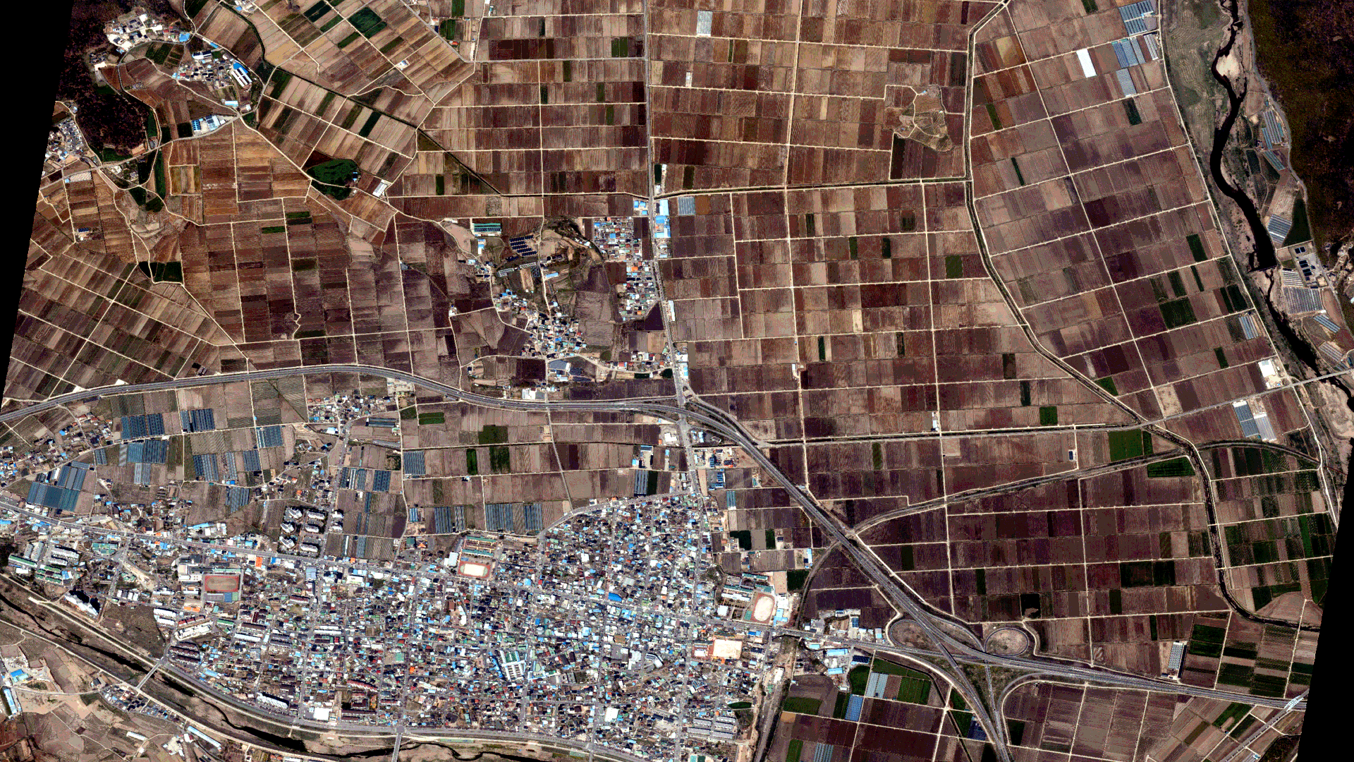
고해상도 위성영상 기반 객체 탐지, 수체 추출, 변화 탐지, 토양수분·식생지수 분석, SAM/GeoSAM 응용.
Open Data Cube, Google Earth Engine, OGC WPS, PaaS/SaaS, 오픈소스 GIS 기반 공간정보 처리 플랫폼.
COG, WMS, WMTS, GeoJSON, 디지털트윈, 웹 매핑을 활용한 대용량 지리공간 데이터 시각화.
국방 및 공공안전 분야의 위성정보 활용 역량 강화를 위한 SAR 데이터 활용, 분석 플랫폼, 실무형 교육 연구.
정보컴퓨터공학 전공 공학박사로, 경민대학교 컴퓨터소프트웨어학과(지능형소프트웨어학과) 교수이며 현재 학과장을 맡고 있습니다. 연구실은 위성영상, 원격탐사, 공간정보 및 AI 기반 데이터 분석 기술을 바탕으로 다양한 위성데이터 활용 기술과 플랫폼 개발을 수행합니다.
2025 Guest Editor, Special Issue: Vegetation Classification and Mapping by Remote Sensing and Machine Learning, MDPI Journal.
Reflectance products, ARD workflows, calibration and validation, and time-series processing for KOMPSAT, CAS500, Landsat, and Sentinel imagery.
Object detection, water extraction, change detection, soil moisture and vegetation analysis, and SAM/GeoSAM applications for high-resolution imagery.
Geospatial processing platforms based on Open Data Cube, Google Earth Engine, OGC WPS, PaaS/SaaS, and open-source GIS stacks.
Interactive visualization of large geospatial datasets using COG, WMS, WMTS, GeoJSON, digital twins, and web mapping technologies.
SAR data utilization, analysis platforms, and practice-oriented education for strengthening satellite information capabilities in defense and public safety.
Professor in the Department of Computer Software / Intelligent Software at Kyungmin University, currently serving as Department Chair. He holds a Ph.D. in Engineering with a major in Information and Computer Engineering. The lab develops satellite data utilization technologies and platforms based on satellite imagery, remote sensing, geospatial information, and AI-driven data analysis.
2025 Guest Editor, Special Issue: Vegetation Classification and Mapping by Remote Sensing and Machine Learning, MDPI Journal.